Bir Tawil: The Desert No Country Wants
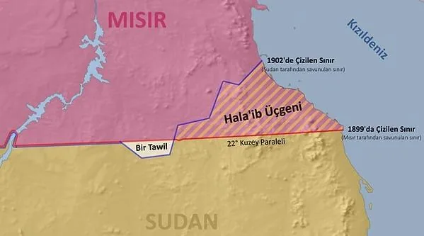
Bir Tawil is a patch of desert on the border between Egypt and Sudan. Neither country claims it. The reason goes back to two conflicting colonial boundary lines, drawn in 1899 and 1902. It is one of the strangest corners of the map: a place that exists precisely because everyone would rather it belonged to someone else. The story of Bir Tawil is not really about sand. It is about how borders get made, how they get gamed, and what happens when the paperwork outlives the empire that wrote it.
Bir Tawil is a desert region between Egypt and Sudan that neither nation claims, because each prefers a different colonial-era boundary that gives it more valuable land elsewhere. The old Iraq-Saudi Arabia Neutral Zone and the microstate Liberland on the Danube show the same pattern. One contested reading of the EU's uneven handling of Kosovo and divided Cyprus is that it reflects interests rather than principles.
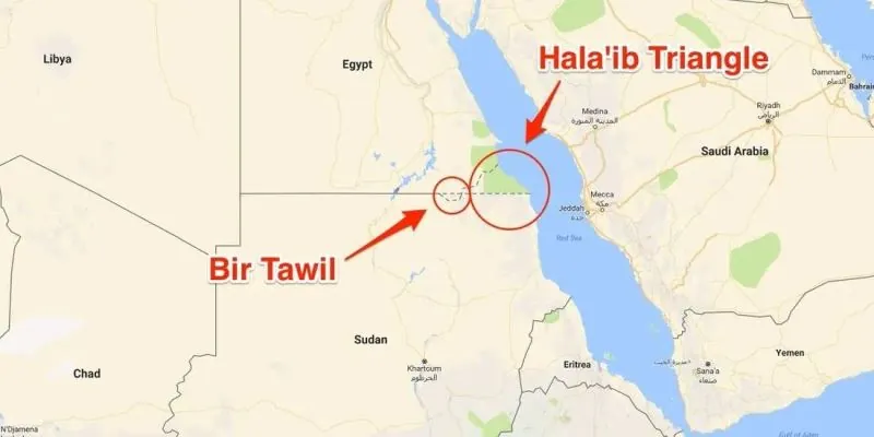
- Bir Tawil sits between Egypt and Sudan and covers roughly 2,000 km² of desert.
- Two British-era boundary lines, one drawn in 1899 and another in 1902, give Egypt and Sudan conflicting claims that leave Bir Tawil unclaimed.
- Egypt keeps the Halaib Triangle under the 1899 line, while Sudan prefers the 1902 line that assigns it Halaib and leaves Bir Tawil to Egypt.
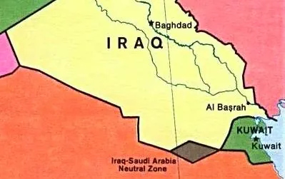
- The Iraq-Saudi Arabia Neutral Zone was a similar administrative compromise, divided between the two countries in 1981 and 1991, after oil was discovered and the Gulf War ended.
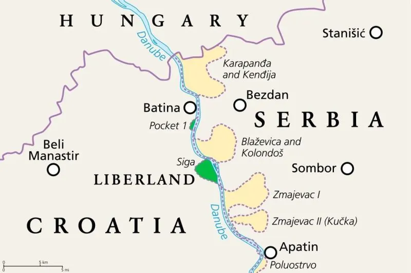
- Liberland, proclaimed in 2015 on a Danube parcel between Serbia and Croatia, is another example of a border dispute creating a patch no state asserts.
The Desert Nobody Wants
Somewhere between Egypt and Sudan sits a triangle of sand and rock about 2,000 km² in size, and not one country on Earth claims it. This is Bir Tawil, one of the rarest things you can find on a modern map: a genuine terra nullius, land that officially belongs to nobody. No flag flies there. No government collects taxes, issues IDs, or pretends to care. It is simply a hole in the world's political fabric, and the reason it exists is almost funny once you see it.
The trouble started with the British, who drew the Egypt, Sudan border twice. In 1899 they ran the line straight along the 22nd parallel, clean and technical. Three years later, in 1902, British administrators decided that straight line was impractical and drew a second, administrative boundary that bent away from the parallel to follow where local tribes actually lived and grazed their animals. Two borders, one stretch of desert, and a century of argument waiting to happen.
So which line wins? That depends entirely on who you ask. Egypt insists on the 1899 line, the 22nd parallel. Sudan insists on the 1902 administrative line. And here is the trick: each position conveniently hands the other country Bir Tawil while keeping the real prize.
That prize is the Halaib Triangle, the valuable, contested land both countries genuinely want. Bir Tawil is the leftovers. Neither Egypt nor Sudan will claim it, because claiming it would undercut their own case for Halaib. A country cannot argue for one border in one place and the opposite border a few kilometers away without looking absurd, so both sides do the only thing that keeps their argument intact. They leave the triangle alone.
Which tells you something about borders in general. They are not natural, not absolute, and rarely fair. They are drawn by diplomatic calculation, and sometimes that calculation leaves a hole in the map, a patch of desert that belongs to no one because it is worth less than the argument it would cost.
The Neutral Zone That Vanished
If you were born in the 1980s or earlier, there is a decent chance a school atlas once showed you a small diamond of blank space wedged between Iraq and Saudi Arabia. No flag, no capital, no shading. Just an empty rhombus sitting in the middle of the desert, quietly labeled as a neutral zone.
That diamond was real, and it had a birthday: 1922. When British officials drew the border of their mandate in Iraq against the young Saudi state, they ran into a problem the desert does not solve. Out in the open sand there was no river, no ridge, no village to anchor a line to. So instead of guessing, they set the whole strip aside for joint use. Call it a diplomatic shrug, written into a treaty.
Here is the strange part. Both countries held claims to it. Neither actually ran it. No governor, no tax collector, no police post. The Neutral Zone was a shared, ungoverned strip of sand that belonged to two flags at once and to neither of them in practice.
Then someone found oil underneath it.
Once there was something worth having down there, the polite arrangement lost its charm. In 1981 the two states carved the zone up between themselves. A decade later, in the shadow of the Gulf War, the 1991 settlement finished the job. The diamond was gone. If you flip open a modern atlas, you will not find it. An entire formally recognized territory, erased from the map in two strokes of a pen.
That is the lesson this little rhombus leaves behind, and it is the same lesson that runs through the story of Bir Tawil: a gray zone can survive for decades on paper, but the moment there is treasure underneath it, the gray does not last. The blank space gets filled in, and usually not by the people who live there.
So the next time you see an empty patch on a map, do not assume it is empty because nobody wants it. Sometimes it is empty because everyone is waiting to see what is buried below.
A River That Moved the Border
Now picture the Danube in the 1940s, curling through Yugoslavia in wide, lazy loops. When the internal border between Serbia and Croatia was drawn in that decade, it followed the river's course as it ran at the time, meander for meander. Then engineers arrived.
Dams went up. Flood control works and canal projects went in. The Danube that had wandered was pushed into a straighter, more linear channel, and the old loops were left behind as dry ground or still backwaters. Here is where the two countries split. Serbia argues the border should track the river's current natural flow, which is the honest line on the ground today. Croatia counters with the 1940s cadastral maps, the official land records that still trace the old, vanished meanders. Neither side is being stubborn for its own sake. Each position happens to favor the territory its government wants.
The practical result is a handful of small patches along the Danube that neither country effectively claims. Not a grand triangle like Bir Tawil, just slivers of floodplain caught between two versions of a map. In 2015 a Czech activist looked at that gap and declared a microstate on it, calling it Liberland. Serbia did not recognize it. Croatia did not recognize it. The self-declared nation still exists mainly as a website and a flag, which is roughly what you would expect for a country whose entire legal foundation is a river that changed its mind.
The EU's Double Standard
Serbia wants into the European Union, and Brussels has attached a condition that cuts to the bone: normalize relations with Kosovo, which in practice means accepting it as an independent state. Here is the wrinkle. Kosovo is still not recognized by five EU member states, Spain, Greece, Romania, Slovakia and Cyprus. So the club demanding that Belgrade swallow Kosovo's statehood cannot get its own members to agree on it.
Cyprus is the sharper example. The island joined the EU in 2004 as though it were a single, united country, even though it was and remains de facto divided. That same year, Turkish Cypriots voted yes on the Annan Plan, the UN blueprint for reunification. Greek Cypriots voted it down. The Republic of Cyprus was admitted anyway, and the EU in practice applies its rules only across the Greek Cypriot south, while the northern presence gets ignored. Brussels took in a divided island as if it were whole, and now asks Serbia to bless a breakaway it will not itself formally bless.
Why does this happen? One reading, and it is contested rather than settled, is that enlargement runs on interests, not principles. On this view, the Kosovo question bends to direct NATO and US influence in the Western Balkans, while the Cyprus question bends to Greek and Greek Cypriot lobbying power inside the EU. What is not contested is the effect on Belgrade: the feeling that joining the EU means trading away territorial integrity. Trust erodes, and anti-Western sentiment finds fresh soil.
Set that next to a place like Bir Tawil, and the pattern is hard to miss. A line drawn in 1899, redrawn in 1902, and two governments still pointing at different maps. Borders look permanent on paper. Up close, they are arguments that never quite ended.
Why the Line on the Map Is Never the Real Line
Look at enough of these orphaned places and a pattern starts to show itself. Bir Tawil, the old Iraq-Saudi Arabia Neutral Zone, the shifting patches along the Danube, the standoff over Kosovo, the strange case of Cyprus: none of these borders came from nature. Every one of them is a temporary diplomatic compromise, drawn by someone with an interest in where the pencil stopped.
Maps feel permanent. They are not. A map is a snapshot of politics and international interests at a single moment, and when those interests move, the map lies about it for decades.
Take the Iraq-Saudi Arabia Neutral Zone. When Britain drew the border for its mandated Iraq in 1922, the desert in the middle was too featureless to split cleanly, so the two sides simply agreed to share it. That diamond-shaped blank sat on classroom maps for generations. Then oil was found, the two countries divided the ground between them in 1981, and the 1991 Gulf War finished the job. The line vanished from the maps, but the politics that erased it never had anything to do with geography.
Bir Tawil tells a similar story from the opposite direction. Britain set the Egypt-Sudan boundary at the 22nd parallel in 1899, then redrew an administrative line three years later to follow where the local tribes actually lived and grazed. Egypt now insists on the 1899 line, Sudan on the 1902 one, and each is happy to hand the other the barren 2,000 km² triangle while fighting for the valuable Halaib Triangle. The result is a piece of land no country claims. Terra nullius, sitting in plain sight.
The Danube runs through the same logic. Yugoslavia drew the Serbia-Croatia border along the river's meandering course in the 1940s, and Croatia still holds those cadastral maps. Dams, flood control and canal works later straightened the water, so Serbia argues the border should follow the river as it flows today. In 2015 a Czech activist planted a flag on the disputed ground and declared a microstate called Liberland. Neither Serbia nor Croatia recognized it, which is exactly the point: you cannot declare your way out of a border dispute.
Kosovo and Cyprus show how selectively any of this gets applied. The EU asks Serbia to normalize relations with Kosovo, which in practice means accepting it as independent, yet five member states, Spain, Greece, Romania, Slovakia and Cyprus, still refuse to recognize Kosovo themselves. Cyprus joined the EU in 2004 as though the island were whole. Turkish Cypriots voted yes to the Annan Plan that year, Greek Cypriots voted no, and the Republic of Cyprus was rewarded anyway. One interpretation, contested rather than settled, is that this looks less like principle and more like interest, with NATO and US influence shaping the Balkans and Greek lobbying shaping Cyprus. The double standard it points to is hard to miss.
So no matter how thickly a border is inked, the real line lives in politics, not on the paper. Draw it, redraw it, erase it: the ground stays the same, and the argument goes on.
Frequently asked questions
What is Bir Tawil and why does no country claim it?
Bir Tawil is a roughly 2,000 km² triangle of desert between Egypt and Sudan that belongs to no country. Egypt insists on the 1899 border along the 22nd parallel, while Sudan backs the 1902 administrative line drawn around tribal grazing grounds. Each position hands the barren Bir Tawil away and leaves the valuable Halaib Triangle to the other side.
Why did the Iraq-Saudi Arabia Neutral Zone disappear?
The zone was created in 1922, when Britain drew the border of mandated Iraq against Saudi Arabia and no precise line could be fixed in the desert, so the area was set aside for joint use. After oil was found, the two states divided it in 1981, and the Gulf War context of 1991 finished the job. It vanished from maps.
How did a Czech activist create the microstate of Liberland?
In 2015, a Czech activist declared a microstate called Liberland on land along the Danube that the Serbia-Croatia border dispute had left unclaimed. The spot exists because the river was once more meandering, and later dam, flood control and canal works straightened its flow. Neither Serbia nor Croatia recognized the claim.
Was Cyprus's 2004 EU accession a double standard for divided states?
Cyprus joined the European Union in 2004 as though it were a united country, even though the island is de facto divided. Turkish Cypriots voted yes to the Annan Plan that year, Greek Cypriots rejected it, and the Republic of Cyprus still acceded. The EU now applies its rules only across the south.
Why does the EU pressure Serbia to recognize Kosovo when five members do not?
EU accession conditionality asks Serbia to normalize relations with Kosovo, effectively accepting it as an independent entity, yet five member states still do not recognize Kosovo: Spain, Greece, Romania, Slovakia and Cyprus. One reading of this, and it is a contested interpretation rather than a settled fact, is that the bloc's enlargement runs on interests rather than principles. Editorial note: Details that remain unconfirmed or disputed are presented as such, and no claim here should be read as a final legal determination.
Got a take on this? Add your voice to the conversation below →
No comments yet. Be the first.